UBC researchers track transit users through Twitter

In a sign of smart tech’s impending influence on municipal planning, researchers at the University of British Columbia have showed how crunching the data on Twitter-using commuters can tell a lot about how to run a city’s transit system.
The smart cities movement, its proponents say, will revolutionize the way cities are run. Sensor technology has improved to the point where connected urban infrastructure is not only helping to usher in the Internet of Things but, combined with the massive computing power available to today’s city managers, allow for more efficient, more integrated and, some would even say, more harmonious cities.
That’s the dream, at least, and while things like municipal trash bins that tell you when they’re full may not be advances of the life-changing variety, developing an efficient and integrated transit system can be, with many seeing the use of big data in relation to mass transit as the centrepiece attraction to the city of the future. Shifting hundreds of thousands of bodies (often grumpy ones) at peak hours on a daily basis is no easy task and thus the key will be to get more and better information on when and where riders are coming and going.
It’s with that mindset that UBC computer scientists developed a way to use social media to map out the commutes taken by Twitter users.
The study —part of a larger initiative at UBC called the Data Science Institute, which focuses on equipping researchers with the tools needed to “fully leverage the potential of big data”— involved analyzing 30,000 geotagged public tweets made in and around the Metro Vancouver area over a three week period. (A small percentage of Twitter users engage the geotagging option on their accounts, which indicates where the person was when sending the tweet.) Researchers used machine learning to create a map of the travel routes of 3,440 separate individuals and found that their movements could be predicted based on the tweet locations.
“We can predict that at this time of day or this day of the year, this many people are expected to go from this point to this point,” says UBC post-doctoral student Saeid Allahdadian to Metro News. “That’s very important for urban planning and other applications, it could help optimize the transportation system to serve them better, but it could also help emergency responders and urban planners prioritize where the greatest number of people might need help.”
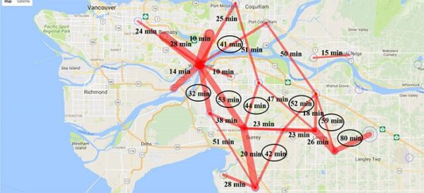
The researchers said that the most popular transit routes were well served by transit options and frequency offered by the city of Vancouver but had some suggestions for improvement. “There were exceptions,” said Allahdadian. “On the Langley-to-Surrey route, travel times can range up to 80 minutes, suggesting a need for faster, more frequent public transit.
Allahdadian added that although social media can offer a wealth of information for city planners, it has its limits. “Twitter users aren’t always willing to share information publicly. They also tend to be young and that can skew results,” he said.