Copper Lake Provides an Update on Gold Potential on Its Marshall Lake Copper-Zinc-Silver Massive Sulphide Property, Northwestern Ontario
Toronto, Ontario–(Newsfile Corp. – October 29, 2025) – Copper Lake Resources Ltd. (TSXV: CPL) (FSE: W0I) (“Copper Lake” or the “Company”) is pleased to announce that further to its news release on October 9, 2025, the Company has identified a number of additional compelling gold geochemical anomalies on its Marshall Lake copper-zinc-silver volcanogenic massive sulphide property (the “Property”), located in northwestern Ontario. The gold anomalies identified emerged from an ongoing assessment of the precious-metals potential at Marshall Lake, undertaken to capitalize on the current high gold price. In some surveys, gold analyses were either not undertaken, were minimal in number, or if completed, were not followed-up on. The objective of this study was to identify new areas prospective for gold, silver and base-metal mineralization from the Marshall Lake database, to assist in future exploration targeting.
The follow-up exploration work on these anomalies will be done in conjunction with the ongoing exploration of the property which is currently focusing on the high-grade copper-zinc-silver intersects in the Teck Hill-Gazooma and Gazooma North-RM-Lease on the western areas of the property (see news release dated February 21, 2025).
Terry MacDonald, CEO commented: “The Marshall Lake property is a large property in a prolific mining area. The property has several zones where there have been some very good drill results over significant widths – some of these dating back decades when the price of gold was $45 per ounce, including these gold anomalies and historic gold drill results that have not been followed up. While we will continue with exploration at the Conductive Centre on the Billiton deposit area, these other zones we are accessible year-round and give us the opportunity to apply the most current geophysics to these areas, and to follow up on the premise that Marshall Lake could be a Noranda style VMS camp with several deposits. We are eagerly looking forward to this next work program and to following up on the promising gold zones.”
An examination of the Property’s geochemical database revealed two surveys that yielded positive results for gold; these include a lake sediment survey and a soil sampling survey as documented below.
Historic Geochemical Survey Results:
Lake Sediment Survey, Dungarvon Resources Ltd., 19811
A lake sediment survey was completed by Dungarvon Resources over the western portion of Marshall Lake on the Property, in the winter of 1981. The survey covered a large area located to the east of the Billiton deposit (see Figure 1). The Billiton deposit hosts a historical resource of 2.2 MT at 4.20% zinc, 1.34% copper & 2.05 oz/ton silver2.
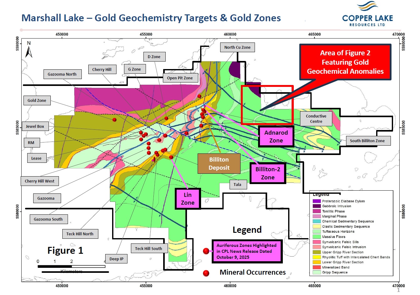
Figure 1
To view an enhanced version of this graphic, please visit:
https://images.newsfilecorp.com/files/4580/272333_gold%20image%201.jpg
Three significant areas with anomalous gold were defined by the survey (see Figure 2). Grid A includes several small gold anomalies with values ranging from 10 to 65 ppb Au. Grid B contains the highest gold values and is the most extensive of the gold anomalies in terms of area. Anomalous gold values for Grid B range from 15 to 200 ppb Au. The Grid C anomaly contains gold values ranging from 10 to 70 ppb Au. Notably, this anomaly coincides with a prominent mercury anomaly (Hg), a common pathfinder element associated with gold mineralization.
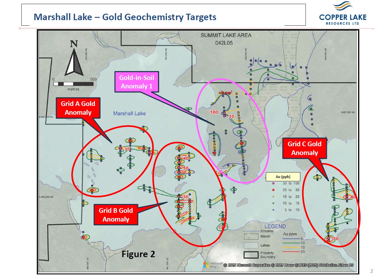
Figure 2
To view an enhanced version of this graphic, please visit:
https://images.newsfilecorp.com/files/4580/272333_gold%20figure%202.jpg
Samples of lake bottom sediment were collected with a cylindrical free-fall sampler at intervals of 30 metres along north-south oriented lines, spaced 328 metres apart over grids A, B and C. Samples comprised a combination of organic gels and non-organic matter, resembling clays in composition. Water depths ranged from 0.6 to 8.0 metres with a total of 421 samples of lake-bottom sediment collected during the survey.
Soil Sampling Survey, Dungarvon Resources Ltd., 19813
A soil sampling survey was completed by Dungarvon Resources in 1991, in the same area of the Property as the lake sediment survey summarized above. A total of 1,131 soil samples were collected in efforts to define prospective target areas on land, peripheral to the large gold anomalies yielded by the lake sediment survey.
Several gold-in-soil anomalies were outlined by the survey, with the most prominent being Anomaly 1 (see Figure 2). Anomaly 1 contains several elevated gold-in-soil values in an area with dimensions of 300 metres by 800 metres and oriented in a north-south direction. Gold values within Anomaly 1 contain 17 sites with gold values ranging from >5 to 100 ppb Au. In addition to gold, this anomaly contains high values for Cu, Pb, Zn and Ag. The author of the report documenting these results stated that ‘a local bedrock source for gold-in-soils was likely’.
Soil samples were collected with a soil auger and were collected in either the A or B soil horizons.
In the case of both the lake sediment and soil sampling surveys, there was no follow-up performed on the anomalous areas containing significant gold values. A follow-up is clearly warranted given that the anomalies represent new areas on the Property prospective for precious and base-metal mineralization, most significant of which are the targets beneath the waters of Marshall Lake.
The content of this press release has been reviewed and approved by Donald Hoy, M. Sc., P. Geo, the Company’s Vice President of Exploration. who serves as the Qualified Person under the National Instrument 43-101 guidelines.
1Report on Follow-up Lake Sediment Survey of Marshall Lake Property, Thunder Bay Mining District, Ontario, for Dungarvon Resources Ltd., by Christoper F. Gleeson, Ph. D., P. Eng., July 27, 1991, 68 pp
2The resource numbers referred to in the Billiton Deposit are considered as historic resources not compliant with NI 43-101 guidelines and therefore should not be relied upon.
3Geochemial Survey of the Marshall Lake Property, for Dungarvon Resources Ltd., Thunder Bay Mining Division, Ontario, by David M. Robertson, B. Sc.(Hons.), October 19, 1991, 126pp
ABOUT COPPER LAKE RESOURCES
Copper Lake Resources Ltd. is a publicly traded Canadian mineral exploration and development company with interests in two projects both located in Ontario. www.copperlakeresources.com.
The Marshall Lake high-grade VMS copper, zinc, silver and gold project, comprises an area of approximately 220 square km located 120 km north of Geraldton, Ontario and is just 22 km north of the main CNR rail line. Copper Lake has an 82.97% interest in the joint ventured property, which consists of 233 claims and 52 mining leases. The project also includes 148 claim cells staked in 2018 and 2020 that are 100% owned and not subject to any royalties. These newer claims add approximately 30 square km to the property.
In addition to the original Marshall Lake property above, Marshall Lake also includes the Sollas Lake and Summit Lake properties, which are 100% owned by the Company and are not subject to any royalties. The Sollas Lake property consists of 20 claim cells comprising an area of 4 square km on the east side of the Marshall Lake property where historical EM airborne geophysical surveys have outlined strong conductors on the property hosted within the same favorable felsic volcanic units. The Summit Lake property currently consists of 100 claim cells comprising an area of 20.5 square km, is accessible year-round, and is located immediately west of the original Marshall Lake property. The Marshall Lake project is located in the traditional territories of Aroland and Animbiigoo Zaagi’igan Anishinaabek (“AZA”) First Nations.
Copper Lake has a 69.79% joint venture interest in the Norton Lake nickel, copper, cobalt, and palladium PGM property, located in the southern Ring of Fire area, is approximately 100 km north of the Marshall Lake Property. The Company filed an updated NI 43-101 in October 2023 with a mineral resource of open pit and underground Measured + Indicated Resources of 1,795,000 tonnes at an average grade of 0.72% NI, 0.69% Cu, 339 ppm Co, 0.52 g/t Pd, 0.17 g/t Pt and containing 28.3Mlbs of nickel and 27.3Mlbs of copper. The Norton Lake property is located in the traditional territories of Eabametoong (“Fort Hope”) and Neskantaga First Nations.
On behalf of the Board of Directors,
Copper Lake Resources Ltd.
Terry MacDonald, CEO
(416) 561-3626
Neither the TSX Venture Exchange nor its Regulation Services Provider (as that term is defined in the policies of the TSX Venture Exchange) accepts responsibility for the adequacy or accuracy of this release
![]()
To view the source version of this press release, please visit https://www.newsfilecorp.com/release/272333