AuMEGA Identifies Major New Anomaly at the Cape Ray Project
Key Highlights
- Major, Untested Anomaly Identified: New anomaly located 500 metres southeast of the Central Zone deposits; never drill tested despite a historical sample of 111.5 g/t gold collected nearby1.
- Central Zone “lights-up”: Largest gold deposit at the Cape Ray Project (“Cape Ray”) exhibits extremely strong conductivity values that match gold-bearing host rocks.
- Pipeline of Opportunities Expands: Other conductive anomalies point to possible new gold-bearing trends in underexplored areas of Cape Ray.
- Near-term Drilling: Fully funded drill program to test the new anomaly scheduled for the fourth quarter 2025.
Edmonton, Alberta–(Newsfile Corp. – October 2, 2025) – AuMEGA Metals Ltd (ASX: AAM) (TSXV: AUM) (OTCQB: AUMMF) (“AuMEGA” or “the Company”) is pleased to report results from its recently completed Airborne Time Domain Electromagnetic (“EM”) survey at the Cape Ray, located along the Cape Ray-Valentine Shear Zone (“CRSZ”) in Newfoundland and Labrador, Canada.
The survey successfully delineated known mineralisation at the Central Zone deposits and, importantly, identified several new highly conductive zones with the potential to represent previously unrecognised mineralised trends.
AuMEGA Metal’s Managing Director and CEO, Sam Pazuki, commented:
“The EM survey delivered exactly what we wanted — clear confirmation that our approach effectively maps known gold mineralisation at Central Zone, while also uncovering multiple new high-quality anomalies. Most exciting is a major target located just 500 metres southeast of our high-grade Central Zone deposits that has never been drilled yet mirrors its geophysical signature. It’s a compelling opportunity that we believe could represent a completely new trend of gold mineralisation at Cape Ray.
“With drilling scheduled for later this year, a fully funded 2025 program, and ongoing work at Bunker Hill and Cape Ray West, we continue to have a strong pipeline of opportunities to drive the next phase of discovery on what I have long believed to be the next major mining district in Canada.”
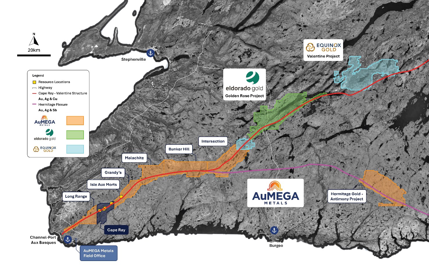
Figure 1: AuMEGA Metals Portfolio on the CRSZ and Hermitage Flexure
To view an enhanced version of this graphic, please visit:
https://images.newsfilecorp.com/files/10713/268850_fc72424bd476f8d4_002full.jpg
Overview
The Cape Ray Project currently hosts 420,000 ounces of gold in Indicated Resources and 141,000 ounces in Inferred Resources, based on a gold price of US$1,750 per ounce2.
In July 2025, the Company completed an airborne EM survey across its mineral resource corridor at Cape Ray. The 930 line-kilometre survey successfully detected conductive zones beneath cover, including graphite and sulphide rich zones that are closely linked with gold mineralisation in the district.
At Cape Ray, the Central Zone deposits are hosted within a graphitic schist horizon in the Windsor Point Group sediments. The EM survey successfully delineated the known Central Zone deposit while identifying multiple new conductive zones that have potential to expand the mineralised footprint.
Many anomalies remain open along strike and at depth, indicating the mineralised system could extend well beyond current resource boundaries.
Major Anomaly Identified
The survey identified a major new EM anomaly with conductivity strength, scale and orientation that is comparable to the Central Zone deposits (Figure 2).
- Located only 500 metres southeast of Central Zone;
- Currently extends at least 1,000 metres along strike and approximately 500 metres wide;
- Remains open along strike, as the EM response continues beyond the edge of the survey limits; and,
- EM anomaly coincides with a significant north to east trending folded structure truncated by a second order splay structure from the CRSZ.
The anomaly is interpreted as a portion of Windsor Point Group sediments, including graphitic schist, thrust into the hangingwall stratigraphy. Most of the known Cape Ray Mineral Resource is hosted in the Windsor Point Group sediments and its graphitic schist horizon is a strong EM conductor. As a result, this target is now classified as a high priority drill target.
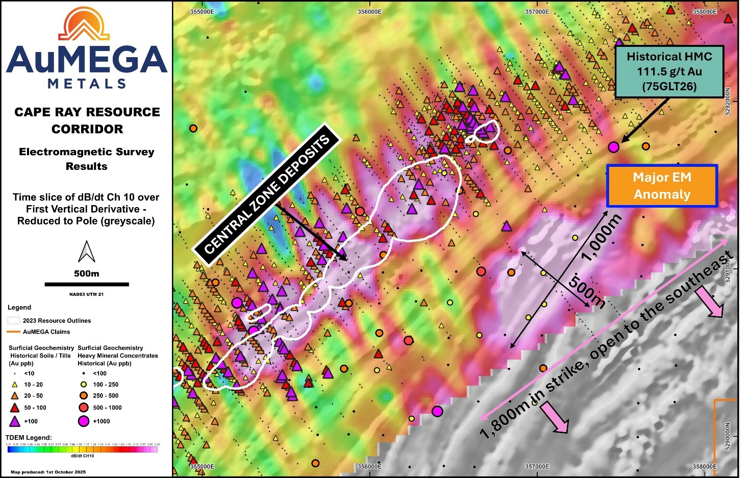
Figure 2: Major EM Anomaly Southeast of the Central Zone deposits
To view an enhanced version of this graphic, please visit:
https://images.newsfilecorp.com/files/10713/268850_fc72424bd476f8d4_003full.jpg
This area, which is almost entirely undercover, has seen limited historical exploration due to its concealed geology, despite the Central Zone access road cutting directly through it. Past work was restricted to sparse soil and till sampling and a broad-spaced Heavy Mineral Concentrate (“HMC”) survey, which returned a standout sample grading 111.5 g/t gold3. The very high-grade sample was collected near the EM source, adjacent to a major second-order hangingwall structure off the CRSZ. Importantly, no drilling has ever been completed in this target area (Figure 2).
With the EM survey now delineating a strong, large-scale conductor in this setting, the anomaly has become a top-priority exploration target. It has the potential to represent an entirely new mineralised trend, comparable to or larger than the existing Central Zone deposits.
Crews are currently on the ground conducting a till geochemical survey, sampling and geological mapping program, with drilling planned before year-end to test this high-impact target. This work is fully funded and markets a key step toward advancing a potential new discovery at Cape Ray.
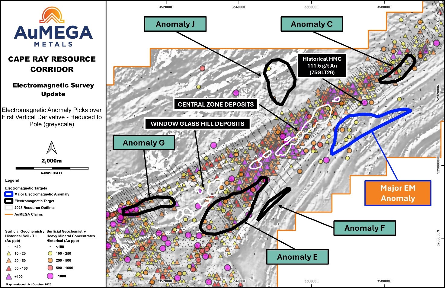
Figure 3: Electromagnetic anomalies adjacent to the Central Zone resource areas.
To view an enhanced version of this graphic, please visit:
https://images.newsfilecorp.com/files/10713/268850_fc72424bd476f8d4_004full.jpg
Several Additional EM Anomalies
In addition to the newly defined large-scale anomaly, the EM survey also delineated multiple additional conductive zones across Cape Ray and along the eastern boundary of the Long Range Project. These anomalies exhibit EM responses comparable to the Central Zone deposits and frequently align with major second- and third-order structures branching off the CRSZ. In several cases, the anomalies are further supported by coincident geochemical signatures, reinforcing their exploration significance and discovery potential.
Key anomalies include:
- Major EM Anomaly (Figure 3 & 4): Located south of Window Glass Hill Granite within Windsor Point Group sediments, the same host sequence that contains most of the Company’s resources. This anomaly sits 300 to 1,500 metres along strike from historical drilling in a structural setting analogous to Central Zone.
- Anomaly B (Figure 4): Situated at Cape Ray West in a position comparable to Central Zone, along the interpreted southeastern boundary of the Windsor Point Group. The combination of strong EM conductivity (graphitic schist) and a favourable structure position mirror the Central Zone setting. First-pass mapping and geochemical sampling were completed in July 2025, with assay results pending.
- Anomaly C (Figure 3 & 4): Lies east of Central Zone, where previous drilling likely tested the wrong horizon. Historical gold-in-soil anomalism coincides directly with this EM response, making it a strong follow-up target.
- Anomaly D (Figure 4): Defined along the southwestern edge of the EM survey with approximately 800 metres of strike, representing a newly recognised trend with minimal historical exploration. The area is supported by a 550-metre-long historical gold-in-till anomaly and a 2023 float sample (MR001585) that graded 4.38 g/t gold, 49 g/t silver, and 1.38% copper4.
These anomalies underscore a growing pipeline of untested targets across Cape Ray that share the same geophysical, geological and structural characteristics as existing deposits, providing multiple pathways for future resource growth.
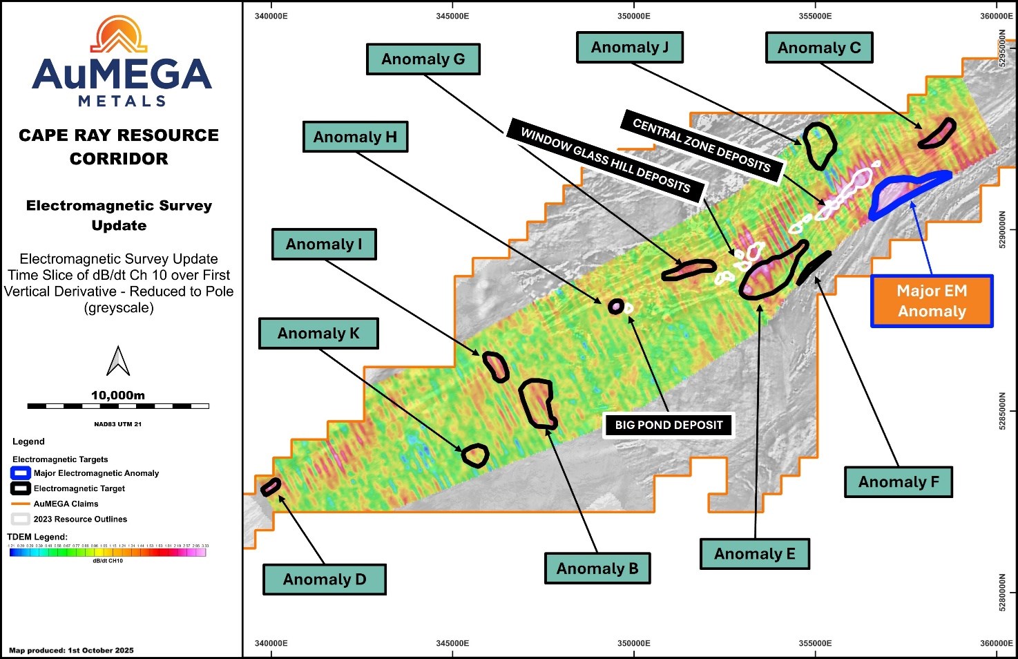
Figure 4: Several EM Anomalies Identified at Cape Ray
To view an enhanced version of this graphic, please visit:
https://images.newsfilecorp.com/files/10713/268850_fc72424bd476f8d4_005full.jpg
AuMEGA is developing detailed work plans to advance these targets in 2025, including:
- Priority surficial geochemical sampling programs on high-priority EM anomalies, highlighting gaps in historical surveys;
- Detailed mapping and rock sampling to refine structural and lithological controls; and,
- Reverse circulation or diamond drilling.
Other
In August 2025, AuMEGA completed an extensive till geochemical survey across the Cape Ray West area, collecting 1,082 till samples and 91 rock samples over 16 km². Historical data confirms a strong correlation between till anomalies and known gold deposits at Cape Ray (Figure 5), underscoring the significance of this dataset.
Pending assay results, expected in the near term, will be integrated with EM and magnetic data to build a multi-layered targeting model supporting the next round of drilling at Cape Ray.
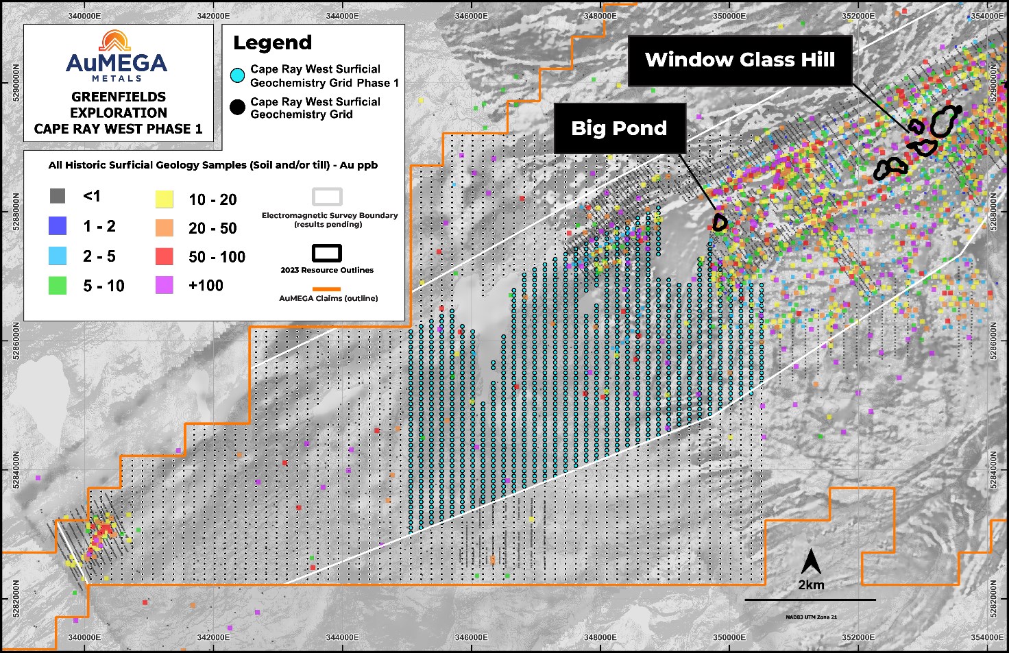
Figure 5: Cape Ray West Till and Rock Sampling Program
To view an enhanced version of this graphic, please visit:
https://images.newsfilecorp.com/files/10713/268850_fc72424bd476f8d4_006full.jpg
< END >
This announcement has been authorised for release by the Company’s Board of Directors.
To learn more about the Company, please visit www.aumegametals.com, or contact:
Sam Pazuki, Managing Director & CEO
Canada Phone: +1 780 665 4925
Australia Phone: +61 8 6117 0478
Email: info@aumegametals.com
About the Company
AuMEGA Metals Ltd (ASX: AAM) (TSXV: AUM) (OTCQB: AUMMF) is utilising best-in-class exploration to explore on its district scale land package that spans 110 kilometers along the Cape Ray Shear Zone, a significant under-explored geological feature recognised as Newfoundland, Canada’s largest identified gold structure. This zone currently hosts Equinox Gold’s Valentine Gold Project, a multi-million-ounce deposit which is the region’s largest gold project, along with AuMEGA’s expanding Mineral Resource.
The Company is supported by a diverse shareholder registry of prominent global institutional investors, and strategic investment from B2Gold Corp, a significant, intermediate gold producer.
Additionally, AuMEGA holds a 27-kilometre stretch of the highly prospective Hermitage Flexure and has also secured an Option Agreement for the Blue Cove Copper Project in southeastern Newfoundland, which exhibits strong potential for copper and other base metals.
AuMEGA’s Cape Ray Shear Zone hosts several dozen high potential targets along with its existing defined gold Mineral Resource of 6.1 million tonnes grading an average of 2.25 g/t, totaling 450,000 ounces of Indicated Resources, and 3.4 million tonnes grading an average of 1.44 g/t, totaling 160,000 ounces in Inferred Resources5.
AuMEGA acknowledges the financial support of the Junior Exploration Assistance Program, Department of Industry, Energy and Technology, Provincial Government of Newfoundland and Labrador, Canada.
Reference to Previous Announcements
In relation to this news release, all data used to assess targets have been previously disclosed by the Company and referenced in previous JORC Table 1 releases. Please see announcements dated: 30 May 2023, 24 August 2023 as well as Newfoundland and Labrador Mineral Assessment Report #011O/0326 submitted by Dolphin Exploration LTD in 1988.
In relation to the Mineral Resource estimate announced on 30 May 2023, the Company confirms that all material assumptions and technical parameters underpinning the estimates in that announcement continue to apply and have not materially changed. The Company confirms that the form and context in which the Competent Person’s findings are presented have not been materially modified from the original market announcement.
Competent Person’s Statements
Geophysics
AuMEGA contracted Axiom Exploration Group Ltd. in conjunction with RPM Aerial Services and Breton Air to fly a TDEM survey using Axiom’s proprietary 30Hz XciteTM TDEM system which collected both time domain electromagnetic and magnetic data simultaneously. Flight lines were spaced 100 metres apart at an orientation of 152-332° with tie lines spaced at 1000 metres at an orientation of 62-242°. The survey covered a total area of 59.5 kilometres2.
Historic Results
Some data disclosed in this news release is related to historical sampling. The company has not independently analyzed the results in order to verify the results; however, the Company considers these historical results relevant as the Company is using this data as a guide to plan exploration programs. The full results of the historical work referenced in this release can be accessed online.
Qualified Person
The scientific and technical information in this press release was reviewed and approved by Shamus Duff, P. Geo., Project Geologist. Mr. Duff is a Qualified Person as defined under National Instrument 43-101 and a Professional Geologist registered with Professional Engineers and Geoscientists of Newfoundland and Labrador (PEGNL). Mr. Duff consents to the publication of this press release and certifies that the information is provided fairly and accurately represents the scientific and technical information disclosed within it.
1 Newfoundland and Labrador Mineral Assessment Report #011O/0326 submitted by Dolphin Exploration LTD in 1988
2 News release dated 30 May 2023
3 Newfoundland and Labrador Mineral Assessment Report #011O/0326 submitted by Dolphin Exploration LTD in 1988
4 News release 24 August 2023
5 News release dated 30 May 2023
![]()
To view the source version of this press release, please visit https://www.newsfilecorp.com/release/268850