Aquitaine Metals Drills Broad High-Grade Gold Mineralization: 16.45 g/t gold over 20.00 metres at Limousin Project
Vancouver, British Columbia–(Newsfile Corp. – October 6, 2025) – Aquitaine Metals Corp. (the “Company” or “Aquitaine”) is pleased to announce the first drill results from the Company’s 2025 Phase 1 drill program at its 100% owned Limousin gold and critical metal project (“Limousin” or the “Project”) in Nouvelle-Aquitaine, France.
Highlights:
-
Results from the first 7 drill holes across the Laurieras structure confirm that high-grade gold mineralization occurs within a broad hydrothermal envelope containing stockwork veins ranging from centimetre- to metre-scale with bulk-tonnage potential.
-
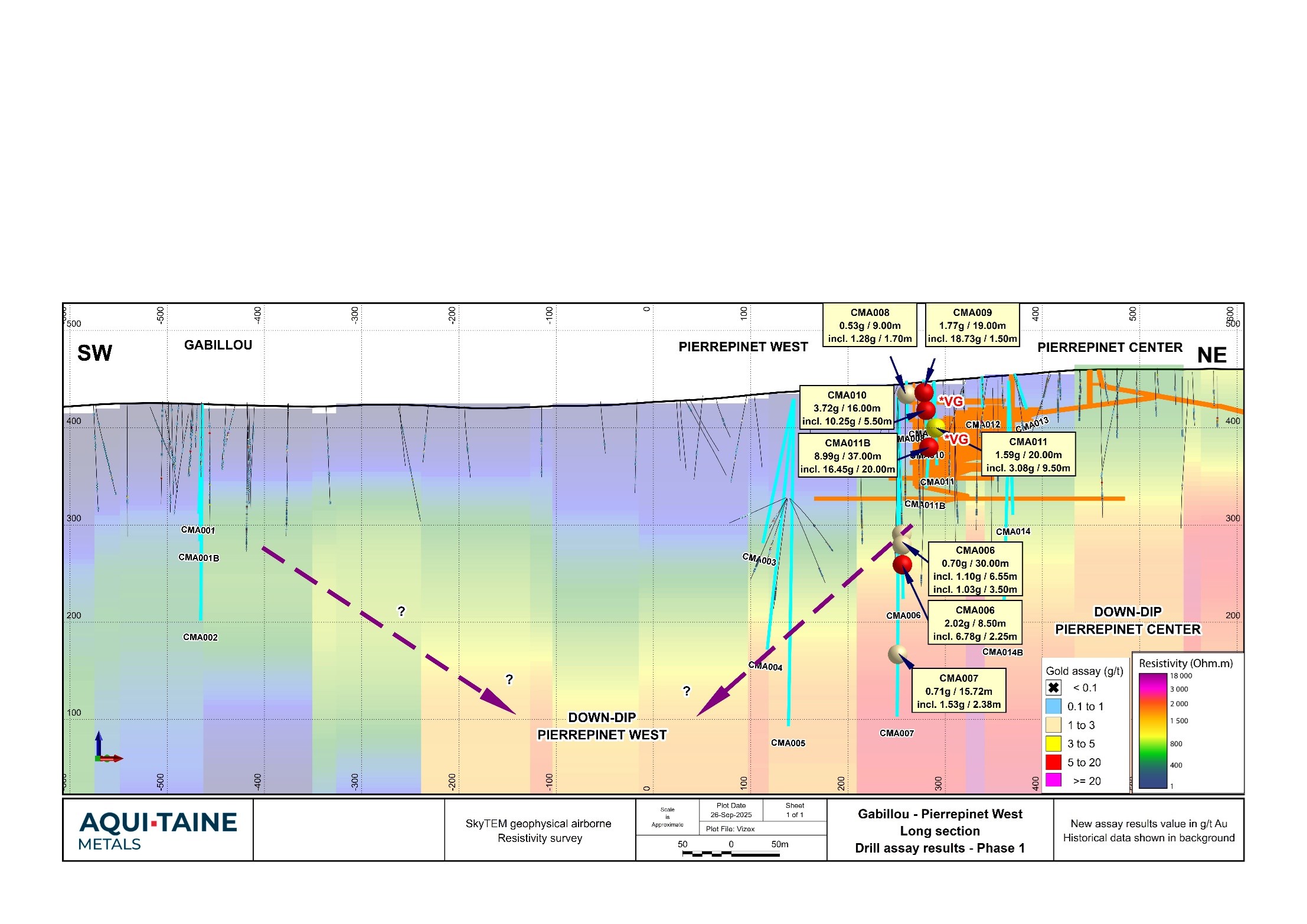
The best result was 16.45 g/t gold over 20.00 metres, including two high grade intervals of 203 g/t gold over 0.50 metres and 202 g/t gold over 0.50 metres all within a broad interval averaging 8.99 g/t gold over 37.00 metres (drill hole CMA011B).
-
Other significant intercepts include 10.25 g/t gold over 5.50 metres, within a broad interval averaging 3.72 g/t gold over 16.00 metres (drill hole CMA010).
-
Deeper drilling confirms the potential for significant gold mineralization at depths beyond what was historically mined or drilled. Drill hole CMA006 intersected 6.78 g/t gold over 2.25 metres at a depth of 65 metres below the historic mining. Drill results and locations are summarized in Table 1 and 2 respectively.
-
The drill program consists of 44 planed holes totalling 8,800 metres, of which 22 holes totalling 4,300 metres have been completed so far. Assays are pending for the remaining 15 drill holes completed to-date and will be released once full results are available.
Chris Taylor, CEO of Aquitaine stated, “We are very encouraged by these initial results, which show grade and width profiles that were until recently not thought to be characteristic of this area. Our team’s expectations of broad mineralized halos around the high-grade gold veins that were historically exploited have been strongly supported. I commend our French staff for their highly professional conduct, and the high environmental and social engagement standards they are employing.
“I look forward to exploring many more of the compelling targets on our Limousin Project along more than 200 kilometres of aggregate strike length of known gold-bearing structures, which host more than 900 exploration targets defined by a combination of ancient and twentieth century gold mines.”
Results and Program Progress:
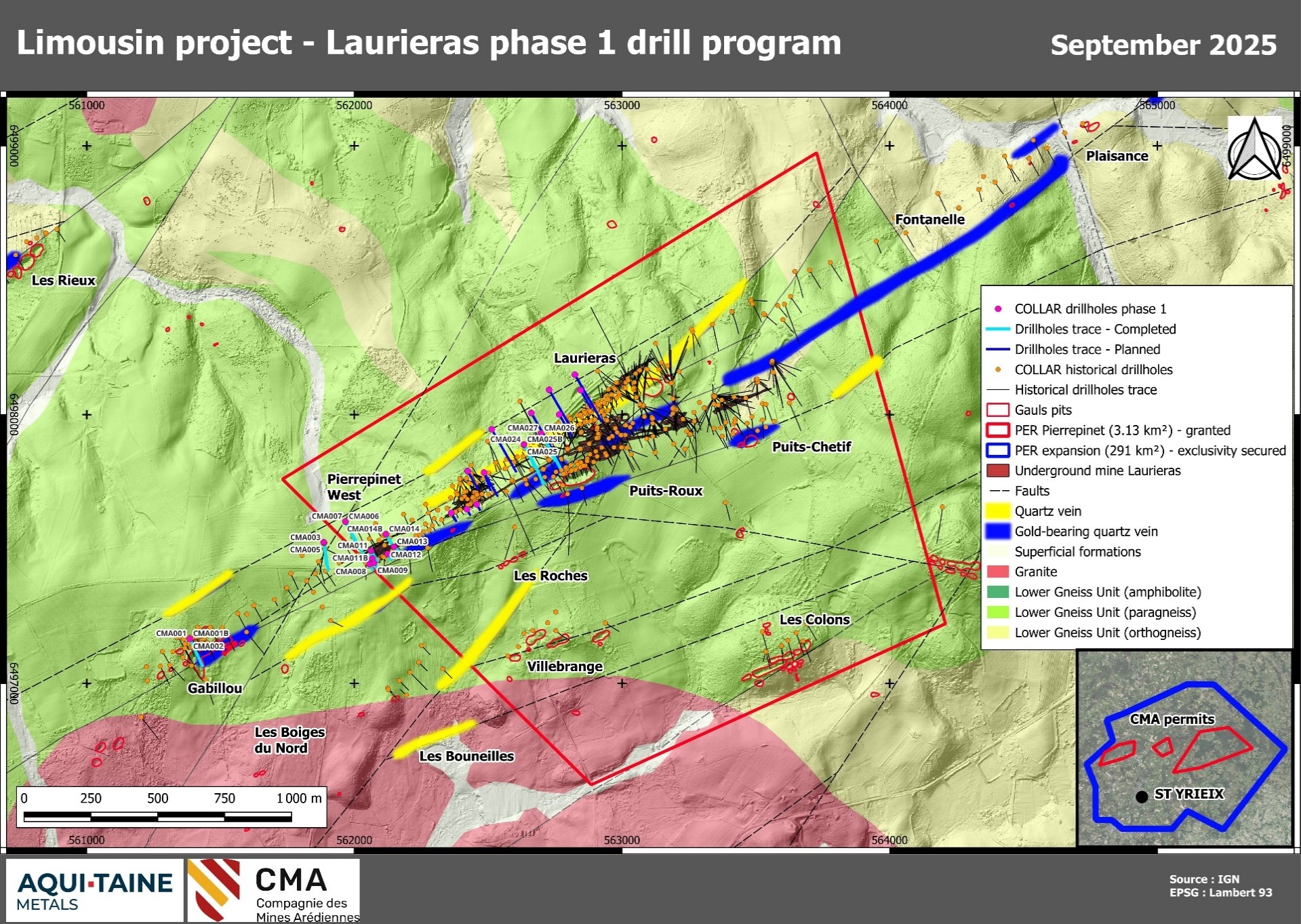
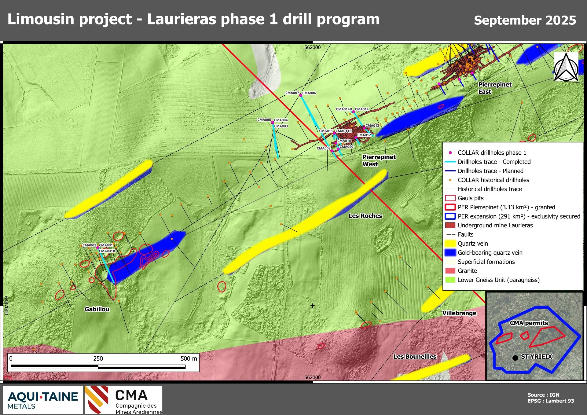
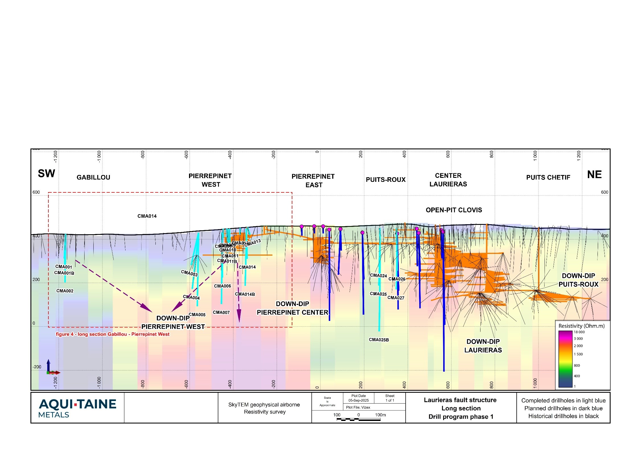
The current drilling program is focused on the Gabillou, Pierrepinet West, Pierrepinet East and Puits-Roux targets located along the Laurieras fault structure. Drilling began in February 2025 and will continue into the autumn. For most of the drill sites, two to three drill holes are aligned in a fan pattern targeting the same gold and critical metal bearing structures, veins, breccias and stockworks at varying depths. Figures 1 and 2 are plan maps of the program and Figures 3 and 4 are long sections of the program.
The main objectives of the program are to confirm the historical datasets acquired by Aquitaine from COGEMA and to test the extensions of ore zones both along strike and down dip from the historical mining.
All reported drill holes have successfully intercepted the gold system as evidenced by quartz veining, sulphide mineralization, widespread alteration and locally visible gold. 36 of the holes totalling 7,320 metres will target mineralized zones along the Laurieras structure covering a strike length of over 2 kilometres, with eight additional holes testing other targets.
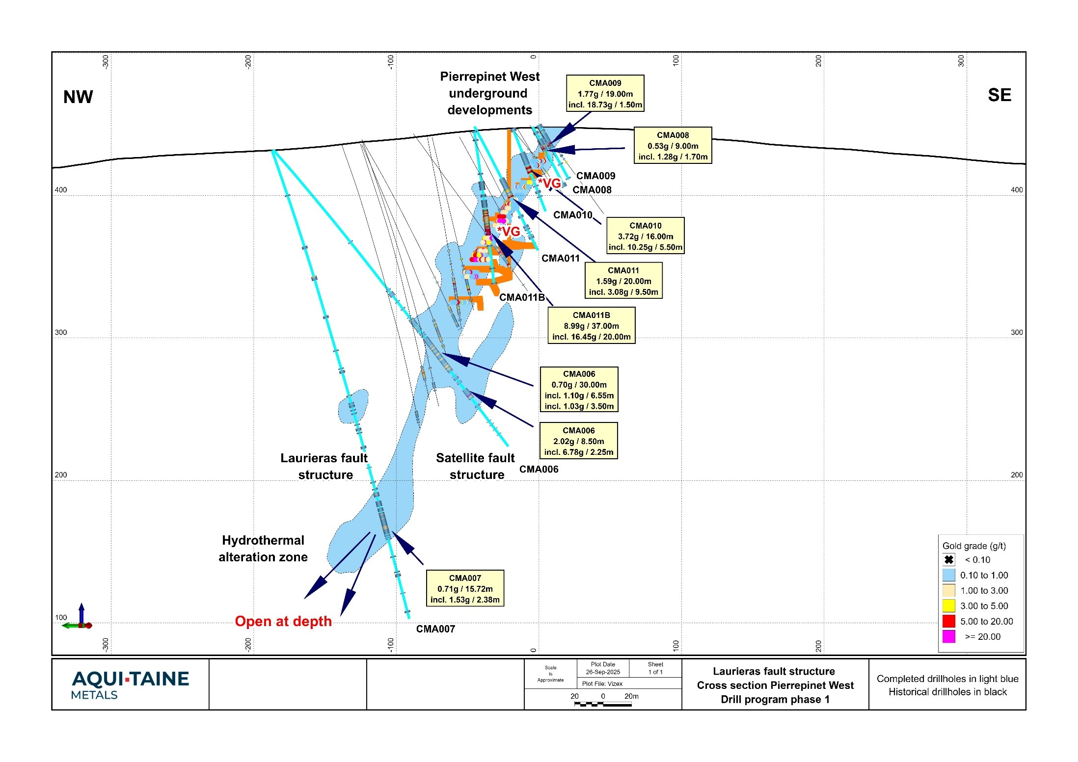
Drill holes CMA011B, CMA010, CMA009, CMA011 and CMA008 confirmed the historical drill results from COGEMA at the Pierrepinet West target while drill holes CMA006 and CMA007 tested the lateral and down dip extension of the Pierrepinet West target, extending the continuity of mineralization 165 metres below the lowest underground mining level.
Results strongly support the Company’s thesis that significant low-grade gold mineralized halos exist around the high-grade veins (Figure 5). Gold mineralization is mainly composed of coarse grains of visible gold and electrum (mm to cm), with accessory pyrite, arsenopyrite, galena, sphalerite, chalcopyrite, tetrahedrite and stibnite (Figure 6).
Table 1: Limousin Project assay results
| Hole ID | From (m) | To (m) | Width* (m) | Gold (g/t) | Silver (g/t) | |
| CMA006 | 152,90 | 159,08 | 6,18 | 0,37 | 0,45 | |
| and | 169,50 | 199,50 | 30,00 | 0,70 | 0,67 | |
| including | 178,30 | 184,85 | 6,55 | 1,10 | 1,28 | |
| including | 194,00 | 197,50 | 3,50 | 1,03 | 0,44 | |
| and | 215,00 | 223,50 | 8,50 | 2,02 | 1,68 | |
| including | 220,00 | 222,25 | 2,25 | 6,78 | 3,97 | |
| CMA007 | 265,28 | 281,00 | 15,72 | 0,71 | 1,10 | |
| including | 275,12 | 277,50 | 2,38 | 1,53 | 1,08 | |
| CMA008 | 10,00 | 19,00 | 9,00 | 0,53 | 5,49 | |
| including | 14,80 | 16,50 | 1,70 | 1,28 | 6,76 | |
| CMA009 | 0,00 | 19,00 | 19,00 | 1,77 | 5,82 | |
| including | 14,50 | 16,00 | 1,50 | 18,73 | 28,57 | |
| CMA010 | 18,00 | 34,00 | 16,00 | 3,72 | 9,79 | |
| including | 28,50 | 34,00 | 5,50 | 10,25 | 23,45 | |
| CMA011 | 41,00 | 61,00 | 20,00 | 1,59 | 49,53 | |
| including | 50,00 | 59,50 | 9,50 | 3,08 | 17,42 | |
| CMA011B | 45,00 | 82,00 | 37,00 | 8,99 | 45,76 | |
| including | 56,00 | 76,00 | 20,00 | 16,45 | 81,08 | |
| including | 69,50 | 70,00 | 0,50 | 203,00 | 412,00 | |
| including | 73,00 | 73,50 | 0,50 | 202,00 | 38,30 |
*Intervals widths are down-hole depths. For most of the drill holes, true widths of mineralization are estimated to be approximately 65-95% of the down-hole interval based on preliminary results, structural observations and historical data. All are diamond drill holes. Vein structures vary in strike between 60 to 70 degrees and dip between 60 to 65 degrees to the northwest. All drill holes intersect both high grade and bulk tonnage domains and often intersect multiple domains within the same drill hole.
Table 2: Limousin Project drill hole locations
| Hole ID | Easting (m) | Northing (m) | Elevation (m) | Azimuth (°) | Dip (°) | Depth (m) |
| CMA006 | 561966,130 | 6497601,480 | 432,06 | 150,00 | -50,71 | 265,50 |
| CMA007 | 561965,687 | 6497602,332 | 431,50 | 151,44 | -70,62 | 342,50 |
| CMA008 | 562055,787 | 6497443,263 | 448,10 | 150,01 | -60,66 | 47,80 |
| CMA009 | 562073,167 | 6497447,928 | 449,50 | 148,57 | -61,54 | 43,80 |
| CMA010 | 562066,785 | 6497465,042 | 446,98 | 150,00 | -69,31 | 62,50 |
| CMA011 | 562062,376 | 6497493,326 | 448,33 | 149,89 | -62,25 | 97,60 |
| CMA011B | 562061,859 | 6497493,252 | 445,145 | 180,16 | -80,48 | 108,50 |
*The coordinate reference system is Lambert 93 (EPSG 2154)
Figure 1: Progress map of the Phase 1 drill program on the Laurieras fault structure.
To view an enhanced version of this graphic, please visit:
https://images.newsfilecorp.com/files/11279/269205_08f3d46f34058ab2_003full.jpg
Figure 2: Detailed map of the Pierrepinet West and Gabillou targets and the progress of the Phase 1 drill program on the Laurieras fault structure.
To view an enhanced version of this graphic, please visit:
https://images.newsfilecorp.com/files/11279/269205_08f3d46f34058ab2_004full.jpg
Figure 3: SW-NE long section showing the progress of the Phase 1 drill program on the Laurieras fault structure. The location of figure 4 is shown by the red outline.
To view an enhanced version of this graphic, please visit:
https://images.newsfilecorp.com/files/11279/269205_08f3d46f34058ab2_005full.jpg
Figure 4: SW-NE long section of the Gabillou and Pierrepinet West targets and progress of the Phase 1 drill program on the Laurieras fault structure.
To view an enhanced version of this graphic, please visit:
https://images.newsfilecorp.com/files/11279/269205_08f3d46f34058ab2_006full.jpg
Figure 5: Cross section of the Pierrepinet West target within the Laurieras fault. Hydrothermal alteration zone outline shown in blue.
To view an enhanced version of this graphic, please visit:
https://images.newsfilecorp.com/files/11279/269205_08f3d46f34058ab2_007full.jpg
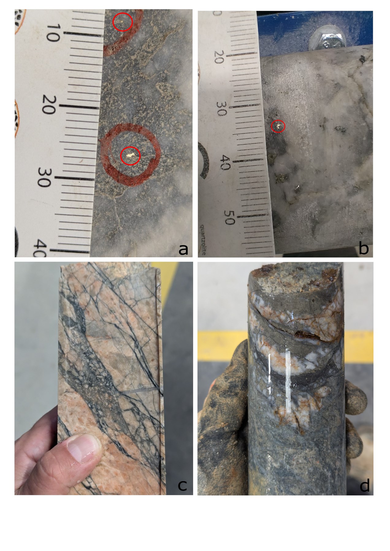
Figure 6: Drill core sample pictures from Phase 1 drill campaign
To view an enhanced version of this graphic, please visit:
https://images.newsfilecorp.com/files/11279/269205_08f3d46f34058ab2_008full.jpg
- White and grey multi-stage quartz vein with visible gold from drill hole CMA005 – 100m in the down-dip extension of the last underground mined level at Pierrepinet West from 283.70 to 284.50m.
- White and grey multi-stage quartz vein with visible gold from drill hole CMA001 – 600m in the south-west lateral extension of the last underground mined level at Pierrepinet West from 81.40 to 82.40m.
- Dark quartz and sulphides (pyrite, arsenopyrite) stockwork developed in a granite with pink potassic pervasive alteration at footwall of the Laurieras structure from drill hole CMA004.
- White quartz vein with sulphides (pyrite, arsenopyrite, galena) crosscutting an intensely sericitized paragneiss from drill hole CMA003.
The Limousin Project
- The project is located in the historic Limousin Mining District in the Region of Nouvelle-Aquitaine, southwest France, 40 kilometres south of the city of Limoges.
- Consists of currently 40 square kilometres of exploration licenses with exclusivity and an additional 290 square kilometers where proposed exploration is in the final stages of review by the French mining administration.
- The Project is comprised of a total 330 square kilometre area of exclusivity, and includes 23 past producing gold mines which operated during the 20th to 21st centuries, as well as over 900 ancient Gallic high-grade gold mining sites that occur along gold-bearing structures stretching along strike for over 200 kilometres.
- COGEMA, a French mining company, operated in the area from 1988 to 2002, producing approximately 1 million ounces of gold with average underground production grades of 12 to 15 grams per tonne gold at a cut off of 10 grams per tonne gold, and mining widths of 3 to 10 metres as well as average open pit production grades of 7 to 8 grams per tonne gold at a cutoff grade of 6 grams per tonne gold.
- Production and exploration records indicate the historical data has an estimated replacement value of $430 million.
- COGEMA ceased exploration in 2002 due to weak gold prices at the time.
- All the gold mines within the area of exclusivity contain significant accessory metals designated as critical by the French state and the European Union, including antimony, copper, zinc and silver.
- Additional zones of massive sulphide mineralization containing high-grade copper, zinc, lead and silver were also intersected by historical miners but saw little exploration at the time. These will also be explored by CMA.
About Aquitaine Metals Corp.
Aquitaine Metals Corp. is a private Vancouver-based gold and strategic metals exploration company that owns 100% of Compagnie des Mines Arédiennes (“CMA”). CMA was founded in 2020 by a team of French mining professionals focused on reviving potentially world class mining projects with economic and strategic importance to the French state. CMA’s exploration activities are focused on its 100% owned Limousin project in Nouvelle-Aquitaine, France. A significant exploration Phase 1 diamond drill program has been underway since February 2025. This work program is designed to confirm historical datasets, and test extensions of the Pierrepinet and Douillac high-grade gold and critical metals ore zones at the Laurieras and Moulin de Cheni mines.
Aquitaine Metals Corp. supports CMA’s vision of a French mining industry renaissance and is a committed partner to all stakeholders, with a long-term vision of sustainable exploration to advance the Limousin project in a manner that demonstrates good stewardship of land, operational excellence and accountability.
Records of work activities, permitting timelines and environmental monitoring progress are available at CMA’s website at: https://www.minesarediennes.fr/.
Aquitaine Metals Corp. is a member of Discovery Group: https://discoverygroup.ca/.
Quality Assurance and Control
All drilling recovers PQ and HQ core. For deep holes, the core size may be reduced to NQ at depth.
Drill core is logged and sampled in a secure core storage facility located in Saint-Yrieix-la-Perche, France. A geologist examines the drill core and marks out the intervals to be sampled and the cutting line. Sample lengths are mostly 0.5 meter in mineralized or hydrothermally altered zones and 1.0 meter outside. Samples are adjusted to respect lithological and/or mineralogical contacts and isolate narrow (<1.0m) veins or other structures that may yield higher grades. Technicians saw the core in half along the defined cutting line using an automatic diamond saw or a hand splitter for intersections with incompetent core. One-half of the core is kept as a witness sample and the other half is submitted for analysis. Individual sample bags are sealed and placed into rice bags, which are then sealed and marked with the contents.
Preparation and analytical work for drill samples is being carried out at the independent ALS Laboratories in Sevilla (Spain) and Loughrea (Ireland), a commercial certified laboratory under ISO/IEC 17025:2017.
Samples are transported by Fedex from CMA’s core storage facility located in Saint-Yrieix-la-Perche to ALS lab in Sevilla, Spain, for sample preparation. Samples are logged in the tracking system, weighed, dried, crushed to 90% passing 2.00 mm screen, riffle split (1,000 g) and pulverized to 85% passing 75 µm. A quartz wash is systematically applied between every sample to reduce or eliminate any contamination during crushing and milling. Prepared samples are then transported to ALS lab in Loughrea, Ireland, by ALS for analysis. All samples are analyzed using a 50 g fire assay (50 g aliquot) with an Atomic Absorption (Au-AA26) finish and multi-element four acid digest ICP-AES/ICP-MS method (ME-MS61). For samples that return assay values over 5.0 g/t gold, another cut is taken from the original pulp (50 g sample) and fire assayed with a gravimetric finish (Au-GRA22). For samples with visible gold or which return assay values over 10 g/t gold, another cut is taken from the original pulp (1 kg sample) and assayed using a metallic screening fire assay (Au-SCR24). Certified gold and multi-element reference standards, blanks and field duplicates are routinely inserted into the sample sequence, as part of CMA quality control/quality assurance program (QAQC). A secure chain of custody is maintained in transporting and storing of all samples. No QAQC issues were noted with the results reported herein.
Drill program design, Quality Assurance/Quality Control, and interpretation of results are performed by qualified persons employing a rigorous Quality Assurance/Quality Control program consistent with industry best practices. Standards and blanks account for a minimum of 10% of the samples in addition to the laboratory’s internal quality assurance programs.
Quality Control data are evaluated on receipt from the laboratories for failures. Appropriate action is taken if assay results for standards and blanks fall outside allowed tolerances. All results stated have passed CMA quality control protocols.
Mineralized Interval Calculations
Significant intervals reported in this news release are calculated as downhole length-weighted intercepts.
Main reported intervals are calculated at a 0.1 g/t gold cut-off grade with up to 2 metres of internal waste for delineating mineralized zones and gold grade*thickness no less than 2 g/t*m.
Included high-grade intervals are calculated a 1 g/t gold cut-off grade with up to 2 metres of internal waste and gold grade*thickness no less than 2 g/t*m.
Table 2 contains a list of all Laurieras holes reported in this release. For most of the drill holes, true widths are estimated to be 65-95% of the downhole widths. Vein structures vary in strike between 60 to 70 degrees and dip between 60 to 65 degrees to the northwest
Qualified Person and NI 43-101 Disclosure
Mr. Andrew Wilkins, PGeo, VP Projects for Aquitaine Metals and the Responsible Officer for Lithos Geological is the Qualified Person as defined by National Instrument 43-101 responsible for the accuracy of technical information contained in this news release. Lithos Geological Inc. has a permit to practice number 1004267 with the Association of Professional Engineers and Geoscientists of British Columbia.
Investor Inquiries
| Chris Taylor CEO and Director Tel. (604) 646-8354 Email. ctaylor@aquitainemetals.com |
John Robins Chair of the Board Tel. (604) 646-4527 Email. jrobins@discoverygroup.ca |
Note on Historical Data
All information related to COGEMA’s mining and exploration activities is believed to be accurate but has not yet been verified by a Qualified Person according to the standards of National Instrument 43-101. Verification sampling and drilling are being undertaken at historical mine sites where exposures are available and included in the current ongoing Phase 1 drill program which started in February. Other historical production data is taken from public records, publications such as Bouchot et al., 2005, and past verification work by COGEMA. It is considered generally reliable for exploration purposes but cannot be verified. Information related to ancient gold production including estimates of historical production grades and total gold produced is taken from archaeological publications, particularly Cauuet et al., 2018, and Baron et al., 2019. Gallic gold mining sites are readily apparent on airborne LIDAR data, from which Aquitaine and CMA’s geologists have reproduced locations and outlines of sites verified and interpreted by archaeologists, and by Aquitaine’s field crews and past explorers at COGEMA.
Cautionary Statement Regarding Forward-Looking Information
This press release contains “forward-looking information” within the meaning of applicable Canadian securities legislation. Forward-looking information includes, without limitation, statements regarding the use of proceeds from the Company’s recently completed financings and the future or prospects of the Company. Generally, forward-looking information can be identified by the use of forward-looking terminology such as “plans”, “expects” or “does not expect “, “is expected “, “budget”, “scheduled”, “estimates”, “forecasts”, “intends”, “anticipates” or “does not anticipate”, or “believes”, or variations of such words and phrases or state that certain actions, events or results “may”, “could”, “would”, “might” or “will be taken”, “occur” or “be achieved”. Forward-looking statements are necessarily based upon a number of assumptions that, while considered reasonable by management, are inherently subject to business, market, and economic risks, uncertainties, and contingencies that may cause actual results, performance, or achievements to be materially different from those expressed or implied by forward-looking statements. Although the Company has attempted to identify important factors that could cause actual results to differ materially from those contained in forward-looking information, other factors may cause results not to be as anticipated, estimated, or intended. There can be no assurance that such information will prove to be accurate, as actual results and future events could differ materially from those anticipated in such statements. Accordingly, readers should not place undue reliance on forward-looking information. Other factors which could materially affect such forward-looking information are described in the risk factors in the Company’s most recent annual management discussion and analysis. The Company does not undertake to update any forward-looking information except in accordance with applicable securities laws.

![]()
To view the source version of this press release, please visit https://www.newsfilecorp.com/release/269205