

Is storm prediction improving?
NASA researchers have come up with a new method of analyzing satellite imagery to detect severe weather patterns. The system uses newly developed algorithms to monitor storm clouds over vast regions in order to predict storms with high winds, hail and tornadoes.
“We are able to analyze the locations where severe storms most frequently occur and when they occur with unprecedented detail using commonly available satellite imagery,” says Kristopher Bedka, physical scientist at NASA’s Langley Research Center in Hampton, Virginia.
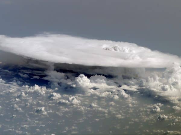
Thunderstorms start with warm, moist air that flows upwards, cooling as it goes and condensing into clouds and water droplets. As these droplets fall back to earth they create a downdraft of cold air that causes the typically high winds associated with thunderstorms. For the NASA scientists, the storm cloud itself -sometimes hundreds of kilometres wide- is key as its shape gives indication of where on Earth the most severe weather can be expected.
“You never really want to fly through turbulence, but you can’t tell a forecaster or a pilot: ‘don’t fly anywhere here,’” says Bedka, pointing at satellite images of cloud tops over southern United States. “That’s half the state of Texas and all of Oklahoma, so you really want to target where within these clouds is most likely to be unsafe.”
Thunderclouds, or cumulonimbus, have flat tops caused by the upwardly flowing air hitting against the stratosphere – the layer of Earth’s atmosphere about ten to 18 km up. In severe weather formations, rapidly rising air punches through the stratosphere, creating “overshooting tops” that look like cauliflower heads poking above the flat upper surface of the cumulonimbus.
It’s these overshooting tops which are the focus of NASA’s efforts, as tracking their development gives more accurate forecasts of severe weather events on Earth. The speed and precision by which NASA’s program can pinpoint storms over huge territories is what’s unique to their system. “We can process an image that covers the entire United States in less than two minutes,” Bedka said, providing valuable information to help communities prepare for storm onsets and to help minimize damage.
Severe weather events can be costly -in 2014, storms across Canada, including the 2013 Alberta floods and the ice storm in southern Ontario, forced insurers to pay out a record $3.2 billion in claims.
NASA plans to launch the GOES-R weather satellite in October, 2016. It will feature the new storm detection algorithms. A collaborative effort of NASA and the U.S. National Oceanic and Atmospheric Administration, the Geostationary Operational Environmental Satellite-R Series aims to provide more accurate and timely weather forecasting and is equipped with many cool-sounding gadgets, such as an Extreme Ultraviolet Sensor, a Megnetometer and, our favorite, the EUVS/XRS Electrical Box.
May 4, 2016, marked the 40th birthday of LAGEOS, a cannonball-shaped satellite launched by NASA in 1976. Still going strong to this day, LAGEOS (short for Laser Geodynamic Satellite) aids in precision measurement of the Earth’s tectonic plates and irregularities in the Earth’s rotation and gravity fields, among others. LAGEOS weighs about 400 kilograms and has no on-board sensors or moving parts but is fitted with an aluminum shell covered with 426 reflectors that allow for precision laser measurement. “LAGEOS is elegantly simple – a ball covered with reflecting prisms,” says Stephen Merkowitz, manager of NASA’s Space Geodesy Project in Greenbelt, Maryland.
The satellite carries a plaque designed by Carl Sagan which bears the images of Earth as it looked 268 million years ago when the continents were all joined together, the Earth as it looks today and, lastly, a projection of how it will look in 8.4 million years when LAGEOS is predicted to fall back to Earth.
About The Author /
Jayson is a writer, researcher and educator with a PhD in political philosophy from the University of Ottawa. His interests range from bioethics and innovations in the health sciences to governance, social justice and the history of ideas.
Leave a Reply
You must be logged in to post a comment.
RELATED POSTS

 Share
Share Tweet
Tweet Share
ShareTRENDING
All Trending →
TTNM keeps “Buy” rating at Haywood
March 20, 2024

NEO stock has price target chopped at Paradigm
March 18, 2024
Groupon’s turnaround is accelerating, Roth says
March 18, 2024
Comment