

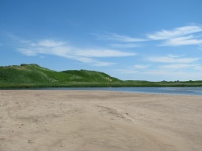
The Nature Conservancy of Canada is bringing Google’s Trekker to the Maritimes this week, where it is currently visiting the north shore beaches of Prince Edward Island, surrounding St. Peter’s Harbour and looking north to the Gulf of St-Lawrence.
Google Trekker is a 50-pound backpack, with a camera system sticking out the top, that captures 360-degree images every 2.5 seconds using 15 cameras, for Google’s Street View.
Eventually, approximately a year from now, internet users will be able to explore spectacular north shore P.E.I. beachscapes, a place which usually offers a “no signal” sign on travelers’ cell phones, from the comfort of their computer, looking at Street View.
The Nature Conservancy of Canada has protected more than 25 hectares of dunes, marshes and shorebird habitat in the area.
The beaches of P.E.I.’s north shore are home to the Piping Plover, a bird that makes its nests in the sand dunes, meaning that they’ve come close to being wiped out by careless teenagers and other visitors to the beaches over the decades.
To remedy that problem, Parks Canada installed a series of wooden walkways and observation points in the late 1990s, keeping visitors to prescribed areas and away from the sensitive Plovers.
The NCC recently planted 2,000 plugs of marram grass in the dunes surrounding St. Peter’s Harbour, helping to protect the dunes from erosion.
On Monday, Luc Thomas, the Trekker with the pack on his back, explored the Murray Harbour area, home of NHL player Brad Richards, to document more of the NCC’s preserved lands.
The Trekker was also in the Bay of Fundy region, documenting the Five Fathom Hole trail, west of Saint John, New Brunswick.
Eventually, the Nature Conservancy of Canada plans to bring Google Trekker to every province, visiting 14 sites across Canada, including the Grand Codroy Valley and Maddox Cove in Newfoundland and Labrador, the Backus Woods in Ontario, and the Laurentians in Quebec.
This summer the Trekker has already been to NCC properties such as Darkwoods, in B.C.’s Kootenay Mountains, Coyote Lake in Alberta, Fairy Hill in Saskatchewan, and two sites in the Westman region of Manitoba.
On Thursday, Google Trekker will travel to Nova Scotia, mapping the Gaff Point hiking trail near Lunenburg, as well as a newly opened pathway at the Pugwash River Estuary, looking north to the Northumberland Strait.
The Nature Conservancy of Canada was formed in 1962, and has protected more than 1.1 million hectares of spectacular landscapes across Canada, including more than 28,000 hectares in the Maritimes.
About The Author /
Leave a Reply
You must be logged in to post a comment.
RELATED POSTS
 Share
Share Tweet
Tweet Share
ShareTRENDING
All Trending →
TTNM keeps “Buy” rating at Haywood
March 20, 2024

NEO stock has price target chopped at Paradigm
March 18, 2024
Groupon’s turnaround is accelerating, Roth says
March 18, 2024
Comment